COASTALT - a short web summary
Altimetry sails closer to the coast
Satellite altimetry, one of the most successful techniques for remote sensing of the oceans, is about to bridge the gap that has so far prevented full use of the data in the coastal zone, that is where the impact of changing climate and rising sea levels is most severely felt by society. New information on coastal dynamics and wave field from altimeters is expected to enable modellers to improve the accuracies of their forecasts. This can have a positive impact on the lives of millions of people, like in the case of storm surge forecasts that can provide vital early warning.
For two decades now, radar altimeters have been mapping the topography of the ocean surface with unprecedented accuracy, also providing valuable information on the wave and wind field in the process. Data in the coastal strip, though, where their interpretation is hampered by land effects on the radar waveforms and intrinsic difficulties with some of the corrections, have traditionally been discarded. This scenario is now changing, thanks to the efforts of a dynamic community of researchers worldwide, supported by the major Space Agencies. ESA is at the forefront of this new field of coastal altimetry having funded COASTALT, a study on the development of altimetry in the coastal zone for Envisat, which started in 2008 and has recently reached completion.
COASTALT and its companion projects, like PISTACH funded by the French Centre National d'Études Spatiales (CNES) for the development of coastal altimetry for the Jason satellites, are rapidly conquering this new frontier for altimetry; their achievements will be under the spotlight at the forthcoming “20 years of Progress in Radar Altimetry” Symposium in Venice, on 24-29 September 2012.
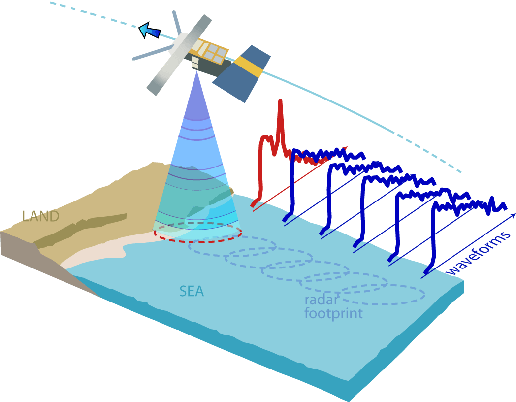
When a satellite altimeter approaches the coast, land entering the radar footprint modifies the shape of the waveforms (as shown by the waveform in red), making the estimate of range and other derived quantities more difficult.
“COASTALT has been both an incubator for some of the most promising coastal altimetry techniques and a catalyst for the coalescence of the new, lively community of international researchers who are collaborating closely on these innovative ideas”, says the COASTALT Project Manager, Dr Paolo Cipollini of the National Oceanography Centre in the UK. “Some of the techniques we’ve explored are still in their infancy and will need further R&D, but others have matured up to a point where we can start applying them routinely to the data and therefore improve the accuracy of the retrieval of oceanographic parameters in the coastal zone”.
Amongst the techniques that have achieved maturity in COASTALT, front stage is taken by an algorithm that compensates for the delay of the radar pulses due to tropospheric water vapour using measurements made by GNSS stations (like GPS and Galileo). Over open ocean this correction, known as the “wet tropospheric correction” is made with dual-frequency measurements taken by the Envisat microwave radiometer, but these become unreliable closer of about 30-50 km from the coast, due to land entering the wide footprint of the radiometer. "In combination with valid radiometer measurements and values from an atmospheric model, the use of GPS measurements to estimate the wet tropospheric effects” says Prof. Joana Fernandes of the University of Porto who has led the development of this new algorithm “allows an effective, accurate correction to be developed all the way to the coastline, dramatically increasing the number of measurements that are recovered”. This correction is now the recommended choice by the ESA Sea Level CCI project for the retrieval of climate-quality measurements of sea level.
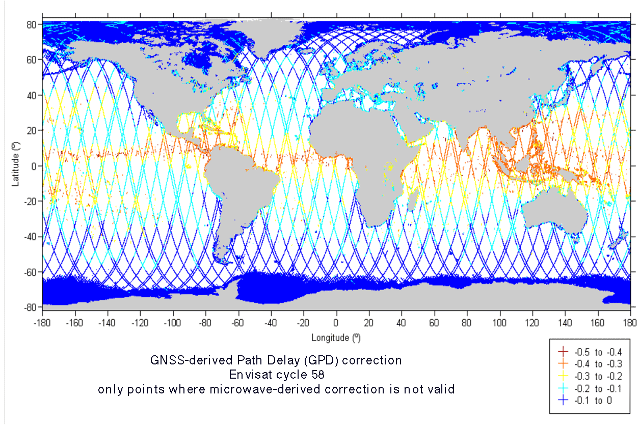
A global map of the wet tropospheric correction (in metres) for Envisat cycle 58, generated with the GPS-based algorithm along those tracks and track segments where the original microwave radiometer-derived correction is not valid. Note the higher (absolute) values in the tropics, where the water vapour concentration is larger.
COASTALT has also explored innovative methods for the processing of the radar waveforms (known as retracking) in the coastal zone. The waveforms often show artefacts due to quasi-specular reflection from ‘bright’ targets (such a target could be a patch of very calm water in a sheltered bay, as the Project has found out in several instances). The spiky signals from these targets migrate along the waveform in a predictable (hyperbolic) manner, and this has allowed the development of a technique that ‘cleans’ a batch of waveforms from such artefacts to improve the precision of the sea surface height and wave height retrieval.
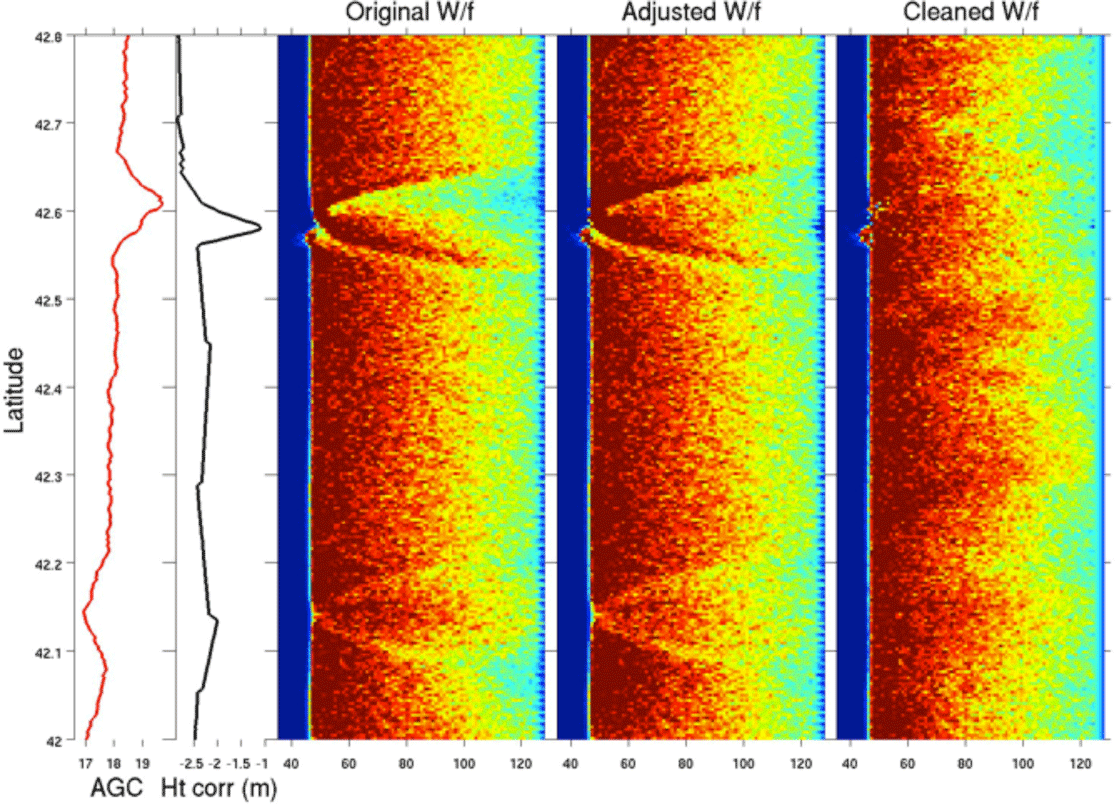
A stack of consecutive Envisat waveforms (each row in the colour maps is a single 20-Hz waveform) for Envisat pass 0257, cycle 073 near Pianosa island in the Tuscan Archipelago (the island is between 42.58°N and 42.60°N). From left: Automatic Gain Control (AGC); Tracker Window position (Ht_corr); Original (uncorrected) waveforms, showing hyperbolic features; waveforms after adjustment of AGC and Ht_corr; ‘cleaned’ waveforms after fitting and removal of the hyperbolic features.
En route to the generation of prototype coastal altimetry products over a number of Envisat tracks around Europe, the project has collected requirements from potential users of the products, converted them into rigorous product specifications and produced an Envisat coastal altimetry user handbook, which will constitute a lasting legacy of COASTALT. The project has also accomplished a significant international coordination role of the new coastal altimetry community, with a substantial contribution to the organization of the Coastal Altimetry Workshops. The 6th edition of the workshop will take place on the shores of Lake Garda, in Northern Italy, on 20-21 September and is fully packed with talks and poster detailing the latest improvements in the techniques and new applications of coastal altimetry.
The COASTALT logo – a stylized depiction of altimetry approaching the coastline
In summary, with COASTALT, ESA has created an asset impacting beneficially on the exploitation of ESA Earth Observation data in the coastal zone, and laying the foundation for future developments that extend coastal altimetry to other missions (like Cryosat-2 and Sentinel-3 whose SAR Altimeters have even more promising performance in the coastal zone) and to applications of high societal impact, like the study of storm surges which is now being carried out by the ESA eSurge Project.
Note to Editors:
COASTALT was ESA/ESRIN Contract No. 21201/08/I-LG led by the National Oceanography Centre, Southampton (UK); other partners consist of the Consiglio Nazionale delle Ricerche, Pisa (Italy); the University of Cadiz (Spain); the University of Porto (Portugal), the University of Lisbon (Portugal), Starlab Barcelona SL (Spain), Hidromod, Lisbon (Portugal), and the National Oceanography Centre, Liverpool (UK). Project Manager: Dr Paolo Cipollini NOC, UK); Project Scientific Officer: Dr. Jérôme Benveniste (ESA/ESRIN, Italy).